DENPASAR, BALINEWSID.COM – The death of hundreds of mangrove trees along the coastal area of Teluk Benoa has sparked growing public concern, with early findings pointing to possible hydrocarbon contamination as the primary cause.
The damage, observed along Jalan Raya Pelabuhan Benoa, first showed signs in September 2025. Mangrove species including Rhizophora, Avicennia, and Sonneratia have exhibited acute ecological stress. Symptoms range from yellowing leaves and necrosis to peeling bark and dried trunks. At least six mangrove sites in the area have reportedly been affected.
The impacted zone lies close to energy pipelines owned by Pertamina Patra Niaga and PLN Indonesia Power. According to the timeline of events, repairs were carried out in September 2025 on a Pertamina pipeline that had previously experienced leakage.
An inspection conducted on December 12, 2025, by PLN Indonesia Power stated that no damage was found on its pipelines. However, inspectors identified a corroded pipe suspected to belong to Pertamina. Pertamina Patra Niaga acknowledged conducting repairs but is alleged to have failed to thoroughly clean oil residues from contaminated soil and sediment following the leakage.
Initial assessments by researchers from Universitas Udayana indicated possible heavy metal and hydrocarbon (fuel) toxicity within the mangrove substrate. Scientifically, such contamination can cause root anoxia and tissue damage, ultimately leading to vegetation death.
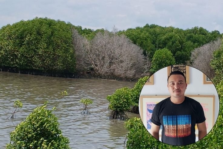
Executive Director of Wahana Lingkungan Hidup Indonesia Bali, Made Krisna Dinata, said the damage pattern strongly resembles hydrocarbon pollution impacts typically seen in coastal ecosystems.
“Scientifically, hydrocarbon contamination in soil is not always visible on the surface. However, its effects can trigger delayed dieback within weeks to months. The pattern in Benoa Bay strongly points in that direction,” Krisna stated.
He argued that claims denying any visible oil spill or strong odor at the site do not automatically rule out pollution. According to him, fuel residues absorbed into the mangrove substrate are even more dangerous because they slowly damage root systems.
“We see this as a strong signal of negligence in handling the leakage. If comprehensive sediment cleanup was not carried out, the risk of large-scale vegetation death is indeed very high,” he stressed.
From a spatial planning perspective, the affected area falls under the Benoa Bay Provincial Strategic Zone and is classified as a “Postponement Zone” under Bali Provincial Regulation No. 2 of 2023 on Spatial Planning. This designation requires strict control of land use and development activities until further determination.
Krisna emphasized that industrial energy operations within mangrove ecosystems must apply the highest precautionary principles. “Vegetation damage caused by industrial activity represents a decline in protective ecological function. If negligence or regulatory violations are proven, this becomes not only an environmental issue but also a matter of spatial governance,” he said.
He also warned that Bali’s ecological condition remains vulnerable. Data from Statistics Indonesia (BPS) Bali for 2023–2024 shows forest cover on the island stands at only around 23–24 percent of total land area, below the ecological minimum standard of 30 percent.
Southern coastal regions such as Denpasar and Badung have some of the lowest forest cover levels. In such an ecological deficit condition, mangrove destruction could trigger compounded impacts, including coastal abrasion, declining water quality, habitat loss for fish and marine species, and increased tidal flooding risk.
“The mangrove dieback in Benoa Bay is a serious warning. If our natural coastal defenses continue to erode due to industrial activity without strict oversight, we are gambling with the ecological future of southern Bali,” Made Krisna Dinata concluded. (*)


Discussion (0)
No comments yet.